Skip to content
.
June 27, 2026
 

Drone Photography for Developers: Better Site Visibility From Site Planning to Final Delivery

Dji fly 20251212 225016 187 1765552054466 photo
Developers have to see the big picture while managing hundreds of moving parts. Drone photography gives commercial, multifamily, residential, and land developers a clearer way to document progress, update stakeholders, and understand what is happening across a site.


How Drone Photography Helps Developers

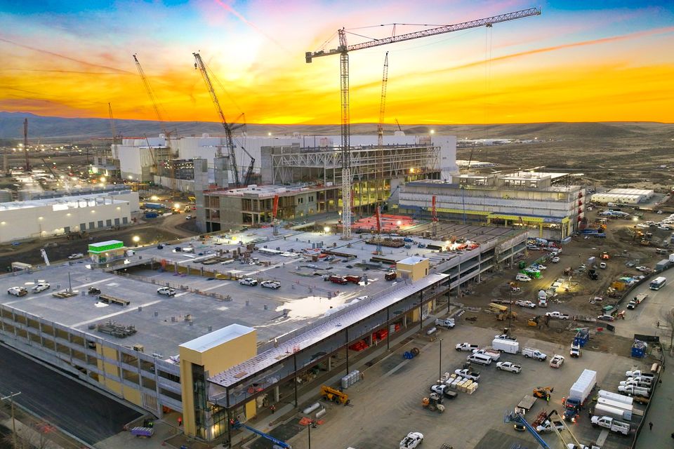
Drone photography helps developers create a clear visual record of a project from site preparation through completion. For Boise and Treasure Valley development projects, drone images and videos help teams monitor progress, communicate with investors, review site conditions, and create polished assets for future marketing.

Key takeaways:
  • Better site visibility: Aerial views show grading, access points, staging areas, building placement, neighboring parcels, and overall site context.
  • Stronger documentation: Recurring drone photography creates a visual timeline from early dirt work through final delivery.
  • Clearer stakeholder updates: Developers can use drone visuals to communicate with investors, lenders, owners, project teams, and future tenants.
  • More useful remote review: DroneDeploy and 360 walkthroughs help off-site decision-makers understand project status without constant site visits.
  • Smarter visual assets: The same imagery used for documentation can often support presentations, leasing, investor updates, and marketing.

Terms and Services

Drone photography for developers: Aerial photos and videos used to document land, construction progress, site conditions, completed structures, and surrounding property context during a development project.

Construction progress documentation: Scheduled visual records that show how a project changes over time. Developers can use these records for owner updates, investor communication, lender reporting, internal reviews, and project archives.

DroneDeploy: A construction reality capture platform used to organize aerial imagery, maps, site documentation, and progress data in one place. DroneDeploy describes its construction tools as a way to capture, manage, and analyze site reality data.
360-degree walkthroughs: Ground-level, interactive site visuals that allow developers and stakeholders to review spaces remotely, document progress, and see areas that standard aerial photos may not capture.

RTK drone imaging: RTK, or Real-Time Kinematic positioning, supports more consistent location data for drone-captured imagery. For development projects, it can help with organized maps, site records, and visual documentation.

Infrared drone imaging: Infrared imaging captures thermal differences that may provide added context during inspections or site reviews. It should be treated as supplemental visual insight, not a guaranteed diagnostic tool.


Why Developers Need More Than Standard Construction Photos
Ground-level photos struggle to show the full development site in context. A developer needs to quickly understand how grading is progressing, where materials are staged, how access points are functioning, what the surrounding roads look like, and how the site sits in relation to nearby parcels.

That is where construction drone photography becomes useful. Developers can depend on and review high-quality aerial visuals that show the project in context.

For commercial and multifamily developers, especially, that wider view can make communication easier. One image can explain site scale, layout, access, and progress faster than a long email.


Drone Photography Helps Developers See the Whole Site
A development site changes constantly. Dirt work starts, access paths shift, materials move, structures rise, and the property begins to take shape.

Drone photography helps document:
  • Site preparation
  • Grading progress
  • Building footprints
  • Parking areas
  • Road access
  • Material staging
  • Surrounding parcels
  • Nearby commercial or residential context

For land developers, aerial photos can show how a property sits within the larger area. For commercial and multifamily developers, drone imagery can help explain progress to people who are not walking the site every week.

This process works alongside surveyors, engineers, architects, and contractors, giving the entire development team a shared visual record of site activity and project progress.


Progress Documentation Creates a Visual Timeline

A single drone shoot is useful. Ongoing drone documentation provides even greater long-term value.

Recurring construction progress documentation [link Construction Progress] creates a visual timeline of the project. Developers can use that timeline to compare phases, review milestones, document completed work, and keep a clean archive from site preparation through final delivery.

This can be especially helpful when a project involves multiple stakeholders. Owners, investors, lenders, leasing teams, and internal decision-makers may all need updates, but they may not need the same level of technical detail. Drone visuals give everyone a shared reference point.

Instead of saying, “The site is moving along,” developers can show exactly what has changed.


DroneDeploy and 360 Walkthroughs Make Remote Updates Easier

Many developers are not on-site every day. Even when they are local, they may be managing multiple projects, investor relationships, design updates, contractor conversations, and timelines at once.

DroneDeploy and 360-degree walkthroughs  can make remote review more practical.

DroneDeploy helps organize visual site
information so teams can review progress in a more structured way. 360 walkthroughs add another layer by capturing ground-level views of the site or interior spaces. Together, they can help developers and stakeholders gain a more complete understanding of site conditions than a standard photo gallery can provide.

This is useful for:
  • Remote owner updates
  • Investor presentations
  • Internal project reviews
  • Pre-construction and mid-project documentation
  • Visual records before work is covered or completed

Drone photography does not replace site visits, but it makes site visits, meetings, and project updates more informed. 
 

RTK and Infrared Drone Tools Add More Site Context

Some projects need more than standard aerial photography.


RTK-supported drone imaging can help create more consistent visual records and maps. That can be useful when developers want organized documentation across multiple flights or project phases.

Infrared drone imaging can add another layer of site context by capturing thermal differences. Depending on the project, this may support certain review or inspection needs.

These tools should be used carefully and explained clearly. They do not replace licensed inspections, engineering judgment, or formal survey work. They do, however, give development teams additional visual information that may support more informed decision-making, stronger documentation, and greater project awareness. 


Investor and Stakeholder Updates Become Easier to Understand

Developers often have to explain construction progress to people who are not builders. Investors, lenders, owners, future tenants, leasing teams, and municipal contacts may all need to understand what is happening without walking the job site.

Drone visuals make those updates easier to absorb.

Aerial photos can show the full property. Drone video can show scale and momentum. Progress photos can show what changed between milestones. Walkthroughs can help stakeholders review details remotely.

The same assets can also support marketing when the timing is right. A clean aerial image of a finished commercial site, retail pad, multifamily property, or residential development can be used for presentations, leasing packages, websites, social media, and future project promotion.

Documentation comes first. Marketing becomes a strong secondary benefit.


Why Developers Should Use a Professional Drone Operator

A drone is easy to buy. Useful construction documentation is harder to produce.

Commercial drone work requires flight planning, site awareness, safety judgment, usable angles, clean editing, and an understanding of what the client actually needs to see.

The FAA states that small drones used for work or business must follow Part 107 rules, and operators must meet certification and registration requirements.

For active development sites, a professional drone operator coordinates around people, equipment, airspace, weather, access limitations, and delivers the type of visuals the developer needs.

Boise Aerial Drone Photography focuses heavily on construction, real estate, commercial properties, rooftop inspections, DroneDeploy, 360 walkthroughs, and aerial documentation across Boise and the Treasure Valley. Owner and operator Josh Garling works closely with developers, contractors, and project teams to deliver clear, professional visuals without adding unnecessary complexity to the process. 


Developer FAQs

What types of developers use drone photography?

Commercial, multifamily, residential, and land developers can all use drone photography. It is valuable for projects of all sizes, but commercial and multifamily developments often benefit the most because they typically involve more stakeholders, longer timelines, investor updates, leasing needs, and recurring documentation. 


When should a developer schedule the first drone shoot?

The first shoot is often most useful before major site changes begin. Early aerial photos create a baseline record of the property, access points, neighboring parcels, and pre-construction conditions. From there, additional flights can be scheduled around milestones.


How often should development projects be photographed by drone?

The right schedule depends on the project timeline and how often stakeholders need updates. Some developers schedule flights around major milestones, while others prefer recurring monthly or biweekly documentation. The goal is to capture meaningful change, not unnecessary footage.


Can drone photography be used in lender or investor updates?

Yes. Drone photos and videos can make lender and investor updates easier to understand by showing visible progress, site context, and completed milestones. They should support formal reporting, not replace required financial, construction, or inspection documentation.


Is drone photography only useful during construction?

No. Developers can use drone photography before construction for site context, during construction for progress documentation, and after completion for leasing, sales, portfolio, and marketing materials.
 

Work With Boise Aerial Drone Photography

For developers in Boise, Meridian, Eagle, Nampa, Kuna, Caldwell, Mountain Home, and the surrounding Treasure Valley, drone photography can make a project easier to document, explain, and present.

Whether you need progress photos, DroneDeploy support, 360 walkthroughs, RTK-supported imagery, infrared drone imaging, or final marketing visuals, Boise Aerial Drone Photography can help create a practical plan for your site.

Call Josh Garling at (208) 912-2963 or schedule a consultation to discuss your development project.